

Base Flood Elevation Explained: Why It Matters and How to Find a Base Flood Elevation
Understand base flood elevation and why it matters. Learn how to read a base flood elevation map for accurate flood risk assessment and planning.
Have you ever attempted to purchase flood insurance, obtain a building permit to build in a flood zone, or examine a flood map? If the answer to any of these is yes, you most likely have heard of the term Base Flood Elevation (BFE). In simple terms, BFE is the estimated height that floodwaters are expected to reach during a base flood, which is a flood that has a 1% chance of occurring in any given year.
BFE is a crucial figure used in floodplain management, insurance pricing, and property development, and something you certainly need to have a handle on in order to ensure that your property is protected from flooding.
Read on to learn about:
- What BFE is and how it’s calculated
- How to find a BFE
- Why BFE matters for flood insurance premiums
- Which flood zones depend on BFE (like AE and VE)
- How homeowners can use BFE to reduce their insurance costs
What is Base Flood Elevation (BFE)?
The BFE is the anticipated elevation of surface water resulting from a flood that has a 1% chance of equaling or exceeding that level in any given year. This is often referred to as the 100-year flood, but that doesn’t mean it is a flood that will only happen once very 100 years. Here are a few key things to keep in mind about the BFE:
- The BFE is typically shown as feet above sea level.
- It helps define high-risk zones on official flood maps.
- Structures below the BFE are considered more flood-prone.
- Regulatory agencies use the BFE to set construction requirements.
- How homeowners can use BFE to reduce their insurance costs
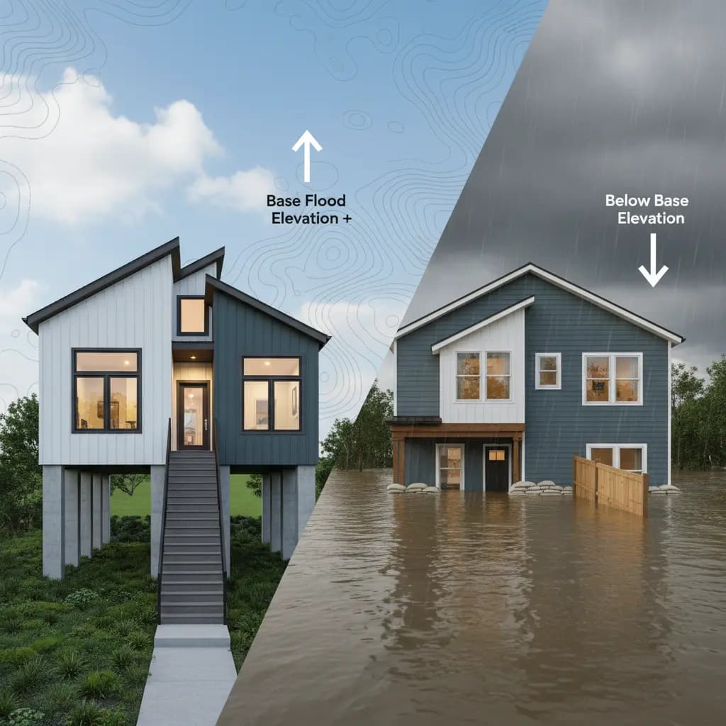
If your home’s lowest floor is below the BFE, it’s at greater risk and will likely face higher flood insurance costs. So, in essence, BFE can be thought of as a ‘flood benchmark’ which is used to gauge the risk that your property faces from flood damage.
How is BFE Determined?
Determining the BFE is a process that involves data, modeling, and expert analysis. It considers parameters such as rainfall patterns and storm intensity, river and stream flow levels, local terrain and elevation, as well as drainage and watershed data. These inputs are fed into hydraulic and hydrologic models to simulate how water behaves during severe storms.
The BFE is typically calculated by engineers hired by federal or local governments, floodplain managers, and community officials, or by the Federal Emergency Management Agency (FEMA).
The result of this process is a detailed flood map showing flood zones and the base flood elevations for those zones.
Why BFE Matters for Insurance
When it comes to flood insurance, the position of your property relative to the base flood elevation or the adjacent ground elevation can significantly affect your annual premium. Here’s how:
- If your lowest floor is below the BFE, your risk and insurance costs rise.
- If your lowest floor is located above the BFE, your risk and insurance costs are reduced.
With the implementation of Risk Rating 2.0, flood insurance pricing is now more property-specific than ever before. Your structure's relationship to the adjacent ground level and/or BFE plays a significant role in determining your premium, even if your neighbor is in the same flood zone.
Zones That Rely on BFE
Not every flood zone has BFE data, but many of the high-risk zones do. Here are the flood zones that use BFE:
- Zones AE, A1-A30Common in river and stream areas; BFE is required for building purposes.
- Zones VE, V1-V30:Coastal areas with high-velocity wave action; includes BFE and wave height data.
- Zones AH and AOShallow flood areas that may include BFE or depth numbers.
Some zones that may not have BFE are:
- Zone A:High-risk, but no detailed BFE unless the community develops one.
- Zone X, B, C:Moderate to low risk; typically no BFE information included.
Understanding whether your zone including BFE helps you anticipate insurance costs and construction requirements.
How to Lower Flood Insurance Premiums with BFE
Just because you’re in a high-risk zone doesn’t mean you’re stuck with high flood insurance premiums. Here’s how the BFE may be able to help you save:
- Build above the BFE: Known as freeboard, even 1–2 feet above the BFE can drastically cut costs.
- Get an elevation certificate: This document officially shows your structure’s elevation relative to the BFE, which may be better than the indicated first floor height used in Risk Rating 2.0 .
- Increase your deductible: If you’re financially prepared for some out-of-pocket costs, higher deductibles often mean lower premiums.
- Install flood vents or retrofit: Improvements that help your home resist water damage can reduce risk ratings.
- Bundle or shop around: Some insurers offer discounts when you bundle flood insurance with homeowners or work through agencies like us.
At Advantage Flood, we guide clients through every one of these steps to help lower their annual flood insurance costs.
Base Flood Elevation vs. Actual Flood Risk
While theBFE is a vital benchmark used by FEMA and insurers, it's important to understand that it doesn't tell the entire story when it comes to flood risk. BFE provides a standardized way to assess floodplain management and insurance pricing, but real-world flooding often doesn’t always follow predictable patterns.
BFE is a Regulatory Tool and Not a Guarantee
BFE is determined from past experience, terrain, rainfall, and hydrology models. However, actual flood events are affected by many dynamic variables that change through time. These are:
- Climate change, increasing the intensity of rainfall and changing weather patterns
- Urbanization, which changes natural drainage and can lead to flash floods in non-traditionally flood-prone areas
- Clogged stormwater drains or overwhelmed drainage
- Coastal erosion or sea-level rise in low-lying areas
These factors allow you to be hit by a harmful flood even if your property is higher than the BFE or outside a high-risk flood zone.
Using BFE + Additional Risk Awareness = Better Protection
An astute homeowner takes into account both BFE and general flood risks:
- Look at adjacent areas and determine how much they have flooded over the last few years
- Evaluate storm drain capacity, rainfall history, and distance from water bodies
- Pay attention to localized risks such as flash flooding or inadequate runoff control
At Advantage Flood, we assist clients in more than just "checking the BFE." We provide detailed property-specific risk assessments so you're covered not just on paper, but in life.
What Homeowners Should Do
If you’re buying a home, building in a high-risk zone, or reviewing your flood insurance , here are some considerations you will want to speak to an expert about:
- Determine your flood zone and BFE using a certified flood map. Advantage Flood can assist you.
- Get an elevation certificate from a licensed surveyor to document how your home compares to the BFE.
- Review your insurance policy and understand how the BFE affects your rate.
- Ask about mitigation options, from home elevation to structural improvements.
- Contact Advantage Flood to explore premium policies based on your unique BFE data.
The more informed you are, the more you can control your insurance costs and protect your property.
FAQs
1). What is BFE?
2). How do I determine the BFE for my property?
3). Is BFE required for flood insurance?
4). What if my home is below BFE?
5). Can I reduce my premium by being higher than the BFE?
Conclusion
The BFE is more than a number on a map. It's an essential measurement that assists you:
- To grasp your actual flood risk
- To plan smarter development
- To potentially reduce your insurance rates
- To meet local regulatory requirements
By learning to interpret the BFE, getting an elevation certificate, and using a reliable service provider such as Advantage Flood, you can explore the best rate options for your situation.


